
Tuesday, August 16, 2011
Stormy Seas
The ship is really rockin' tonight. There is a storm which is driving ~40 knot winds ~40 degrees off of the bow. Peter did a quick (although suspect) calculation and determined that as a result of the storm we will not lose much time. Time is very important as if all goes well we will have roughly 48 hours in the survey area south of Panama. Speaking of time I thought it would be a perfect time to follow up Mackenzies story of the ping edits with a view of swath sonar data that due to the storm will need to be edited. The roll (side to side), pitch (front to back), and yaw (up and down) actions of the ship cause the multibeam to miss pings as they return which causes "noise" in the data. Aside from that all is well.
 Till next time, James

Monday, August 15, 2011
Day Six: The Witching Hour
It is the night shift here on the Melville, and once again I find myself in the main lab with a very tired Dr. Lonsdale and Jasmeet. But I think we all are finally used to our abnormal sleeping schedules. Currently, we are chugging along a nice fault scarp next to a huge deep ocean trench, which should yield some interesting bathymetry. I am definitely learning a lot, and increasing my intellectual worth.
Aside from monitoring the CHIRP, multibeam, and magnetometer, we also finished up editing what are called "ping files". When you drive over the sea floor, the multibeam creates a swath, and each ping the beam sends out is logged as data into a file. The beam, however, picks up a lot of extra fuzz on the sides, which can give inaccurate bathymetry. Our job then becomes to edit each file, and make sure the swath looks okay, so that it gives accurate data once it's on the map.
As far as wildlife goes, I still have yet to see any dolphins or whales. I seem to sleep through all the really good stuff. However, I did see two sea turtles, and the flying fish never cease to amaze me. Everyone on the crew is becoming more gregarious around me, and the cook even gave me a few smiles yesterday. I think it's because I eat a lot of his food, which is ridiculously good. If you do not like his food, you are most definitely not human. I worked out on the bike below decks just now before the midnight shift, which produced a weird feeling of boat-rocking vertigo as well as the usual sweaty uncomfortable feeling that comes with working out. Fun.
Science calls, so until next time!
Mackenzie
Aside from monitoring the CHIRP, multibeam, and magnetometer, we also finished up editing what are called "ping files". When you drive over the sea floor, the multibeam creates a swath, and each ping the beam sends out is logged as data into a file. The beam, however, picks up a lot of extra fuzz on the sides, which can give inaccurate bathymetry. Our job then becomes to edit each file, and make sure the swath looks okay, so that it gives accurate data once it's on the map.
As far as wildlife goes, I still have yet to see any dolphins or whales. I seem to sleep through all the really good stuff. However, I did see two sea turtles, and the flying fish never cease to amaze me. Everyone on the crew is becoming more gregarious around me, and the cook even gave me a few smiles yesterday. I think it's because I eat a lot of his food, which is ridiculously good. If you do not like his food, you are most definitely not human. I worked out on the bike below decks just now before the midnight shift, which produced a weird feeling of boat-rocking vertigo as well as the usual sweaty uncomfortable feeling that comes with working out. Fun.
Science calls, so until next time!
Mackenzie
Day 4 (on Day 5): the East Pacific Rise

On a more important note: I just realized (reading my title) that I may have a future in geo-poetry. Well, probably not, but at least I just made up the term for it - I think I'll start a Wikipedia page...
-Andy
Day 5 and Sounding!
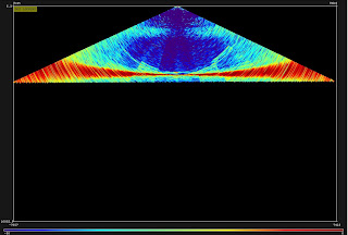
It's very interesting being at sea. I find that when I am not working I have a lot of time for contemplation. This is important for someone like myself who's about to enter his senior year as to what it is that I truly want to do? I find Marine Geology by way of sound fascinating, and this cruise (aside from the fact that I have been writing/fine tuning script for the last 4 days) only affirms that this is what I would like to make my lifes work. Now for some science! Below are images created by the EM-122 multi-beam sonar. The first is a 3D rendition of the latest pings as we progress south to Panama. The second is a side view of the sonar propagation through different levels of the water column. Lastly I have a screen shot of the SVP (Sound Velocity Profile) of our latest XBT. To plot it the temperature is measured as a function of time to a depth of 1000 meters. A salinity profile is then applied to the curve and from it we get sound speed through the water column. This is not an exact measurement, however, we do our best to be careful in it's deployment as a small difference when integrated over the depth may lead to large errors. As I said in the ship tracker we crossed the East pacific Rise yesterday evening and my shipmate Andy can't wait to talk about it. So enjoy the screen shots and bye for now.

 ~James


Saturday, August 13, 2011
Day Three: Bowditch, On Watch
We're all adjusting to our watch schedules, 4 hours at a time, every twelve hours. Beyond the array of computer screens that we monitor, we have a new assignment: reading chapters from the Bowditch manual on navigation--in preparation for our celestial navigation class to come (compliments of the Chief Mate) and the possibility (hopefully never realized) of navigating lifeboats and/or passing through a tropical cyclone. It's definitely great to learn more about all things nautical; we are apparently to be tested--theoretical or practical, TBD.
Last night's watch was rather exciting, as we decided to launch an XBT (Expendable Bathythermograph), in order to determine the thermocline (change in temperature with depth) of the surrounding waters. It starts off with anticipation--there's a cartridge loaded onto a XBT-gun. Novices are warned of the recoil and the sound. When launched, however, it falls gently into the ocean, with little flare. As it falls at 6 knots, the XBT provides a profile of the temperature, which is key in determining the speed of sound, which then informs the seafloor depth given by Multibeam and CHIRP.
Speaking of watches, some of us helped sight and photograph a rare bird, identified by our resident bird-watching expert. It is a Socoro Mockingbird, likely blown off its little island by a hurricane, and finding refuge on the Melville Deck. We do hope he sights land, and finds his way there.


--Jasmeet
Last night's watch was rather exciting, as we decided to launch an XBT (Expendable Bathythermograph), in order to determine the thermocline (change in temperature with depth) of the surrounding waters. It starts off with anticipation--there's a cartridge loaded onto a XBT-gun. Novices are warned of the recoil and the sound. When launched, however, it falls gently into the ocean, with little flare. As it falls at 6 knots, the XBT provides a profile of the temperature, which is key in determining the speed of sound, which then informs the seafloor depth given by Multibeam and CHIRP.
Speaking of watches, some of us helped sight and photograph a rare bird, identified by our resident bird-watching expert. It is a Socoro Mockingbird, likely blown off its little island by a hurricane, and finding refuge on the Melville Deck. We do hope he sights land, and finds his way there.


--Jasmeet
Friday, August 12, 2011
Day two, part two.
As Brad mentioned previously, things are settling in a bit in many ways (mostly in our work/eat/sleep routine), but we're also coming upon some interesting geomorphology: Inactive spreading ridges. At the moment, we're transiting between the Rosanna and Rosa ridges - two in a system of seven en-echelon ridge/transform zones off the coast of Baja California Sur. We are, as I write, recording the magnetic field associated with the oceanic crust, which, when combined with precise laboratory dating of rock specimens, tells us about the history of such ridges. Previous studies have found that these ridges were active producing new oceanic crust from approximately 12 to 6 million years ago, and are interpreted as excellent evidence of microplate capture, a theory which helps explain, for example, the development of the San Andreas fault hundreds of kilometers away.
Andy
Andy
Technically challenging, (un)turbulent, titillating day TWO
This morning, a baffling rumor began circulating: it seems that, after a day, we are in fact a day behind. Besides the mathematical questions such a conclusion might raise, even more profoundly inexplicable is the fact that the situation seems remarkably mundane. We're a day behind, and we still keep the same watches and follow the same protocols. I wonder, given our track record, whether by our twelfth and final day we will be twelve days behind? Perhaps, though, our already spectacular weather conditions will improve, our efficiency will increase more than tenfold, and we will arrive only two days late. It is, I think, a valid question, but only in the same baffling context from which the rumor was born.
Of course, I speak (primarily) in jest, although our fantastic weather, friendly crew, excellent food have not been uninterrupted by technical issues. The last 24 hours (indeed, nearly two-thirds) of our multibeam bathymetry data have been compromised by a false stairstepping effect introduced as a relic of the equipment's transmission sectors. Think of an equilateral triangle, point up, which is divided into eight equal sections with dividers converging at the upper point. Each division represents a transmission sector, and each is transmitted from a single source on the boat (represented by that upper point). Our problem occurs at the divisions of each of these sectors...the leftmost edge of one sector, for example, returns a depth that is offset by a constant value from the rightmost edge of the sector to the left of the first (close your eyes and visualize). The problem is less of an issue here, where our data are merely an addition to the relative plethora of bathymetric data in this area compared to our destination south of Panama.
We've all largely adjusted to life on the ship: meal times have become more intuitive, more of the ship has been explored (a tour of the engine room is supposedly in the works), and we are beginning to work our watches more independently. So far, life is interesting and exhausting...however I reserve final judgement for the flight attendants on my way home, who will almost certainly not re-transmit my almost certain oncoming contempt for not only oceanography, but science in general. Okay, okay, not true: I find bathymetry and magnetic anomalies perhaps awkwardly enthralling.
Brad Peters
Of course, I speak (primarily) in jest, although our fantastic weather, friendly crew, excellent food have not been uninterrupted by technical issues. The last 24 hours (indeed, nearly two-thirds) of our multibeam bathymetry data have been compromised by a false stairstepping effect introduced as a relic of the equipment's transmission sectors. Think of an equilateral triangle, point up, which is divided into eight equal sections with dividers converging at the upper point. Each division represents a transmission sector, and each is transmitted from a single source on the boat (represented by that upper point). Our problem occurs at the divisions of each of these sectors...the leftmost edge of one sector, for example, returns a depth that is offset by a constant value from the rightmost edge of the sector to the left of the first (close your eyes and visualize). The problem is less of an issue here, where our data are merely an addition to the relative plethora of bathymetric data in this area compared to our destination south of Panama.
We've all largely adjusted to life on the ship: meal times have become more intuitive, more of the ship has been explored (a tour of the engine room is supposedly in the works), and we are beginning to work our watches more independently. So far, life is interesting and exhausting...however I reserve final judgement for the flight attendants on my way home, who will almost certainly not re-transmit my almost certain oncoming contempt for not only oceanography, but science in general. Okay, okay, not true: I find bathymetry and magnetic anomalies perhaps awkwardly enthralling.
Brad Peters
Subscribe to:
Posts (Atom)